


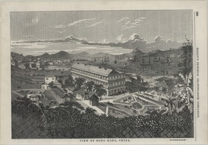
141、 View in Hong Kong
CollectionAntique Maps of China Subjects Botanical Garden (Hong Kong, China) Pictorial works Government House (Hong Kong, China) Geographic region Victoria Harbor (Hong Kong, China) Hong Kong Victoria Harbor 維多利亞港 香港 中國 NoteTear sheet Tex...
更多: 国图 知网万方 上海图书馆 抗日战争与近代中日关系文献数据平台 国图▪文津 籍合网 京东
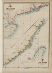
142、 Coast of China
CollectionAntique Maps of China Map makers Weller, Edward, -1884 Day & Son SubjectsCoasts Geographic region China, Southeast 中國東南部 Note Scale not given (E 109°--E 122°/N 17°--N 29°) Depth shown by soundings The Dispatch Atlas [Section...
更多: 万方数据 国图▪文津 籍合网 国图 上海图书馆 京东 知网万方 抗日战争与近代中日关系文献数据平台

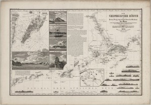
143、 China sea
CollectionAntique Maps of China Map makersJ & C Walker (Firm) Subjects Nautical charts Maps Geographic region South China Sea Southeast Asia Note Scale 1:1,500,000 (E 103°--E 120°/N 12°--S 1°) First published in 1859 with corrections ...
更多: 上海图书馆 孔夫子旧书网 万方数据 国图▪文津 知网万方 籍合网 抗日战争与近代中日关系文献数据平台 国图
144、 View of Hong Kong, China
CollectionAntique Maps of China Subjects Murray House (Hong Kong, China) Pictorial works Geographic region Victoria Harbor (Hong Kong, China) Hong Kong Victoria Harbor 美利樓 維多利亞港 香港 中國 NoteTear sheet consists of p 160, removed from Ballou ...
更多: 知网万方 籍合网 国图 孔夫子旧书网 国图▪文津 上海图书馆 抗日战争与近代中日关系文献数据平台 万方数据 京东

145、 Plan of the attack & bombardment of Canton
CollectionAntique Maps of China Map makersWyld, James, 1812-1887 Geographic region Guangzhou (Guangdong, China) Guangdong Guangzhou 廣東 廣州 Note Scale ca 1:23,000 Hand colored "Drawn by permission from the Plan of the "Times Special Correspo...
更多: 万方数据 国图▪文津 孔夫子旧书网 抗日战争与近代中日关系文献数据平台 京东 籍合网 国图 上海图书馆

146、 Canton and its approaches, Macao and Hong Kong
CollectionAntique Maps of China Map makersBelcher, Edward, Sir, 1799-1877 SubjectsNautical charts Geographic region Zhujiang Kou (Guangdong) Guangzhou (Guangdong, China) Macau (Special Administrative Region) Macau (China : Special Administr...
更多: 知网万方 京东 抗日战争与近代中日关系文献数据平台 上海图书馆 孔夫子旧书网 万方数据 国图

147、 China and Burmah
CollectionAntique Maps of China Map makers Rapkin, J John Tallis & Company Geographic region China Burma 中國 Note Scale ca 1:3,000,000 Relief shown by hachures Published in: Tallis s Illustrated atlas LanguageEnglish Call numberG7820 ...
更多: 京东 国图▪文津 上海图书馆 知网万方 国图 籍合网 抗日战争与近代中日关系文献数据平台 孔夫子旧书网 万方数据

148、 Asia
CollectionAntique Maps of China Map makers Rapkin, J John Tallis & Company Geographic regionAsia Note Scale [ca 1:52,000,000] Relief shown by hachures Hand colored Published in: Tallis s Illustrated atlas Includes vignetts of Tartars, ...
更多: 抗日战争与近代中日关系文献数据平台 孔夫子旧书网 万方数据 籍合网 国图▪文津 知网万方 京东

149、 Hong Kong &c. as seen from the anchorage
CollectionAntique Maps of China Map makers Heath, Leopold George, Sir, 1817-1907 Great Britain Hydrographic Dept SubjectsAerial views Geographic region China Hong Kong 中國 香港 Additional titles由停泊處所見之香港等島嶼 Note Shows points of interest "Sol...
更多: 国图▪文津 国图 万方数据 抗日战争与近代中日关系文献数据平台 孔夫子旧书网 籍合网 京东

150、 Carte des côtes orientales de Chine : Dressée d'après les matériaux les plus récents
CollectionAntique Maps of China Map makers France Ministère de la marine et des colonies France Dépôt général de la marine SubjectsCoasts Geographic region China Taiwan Additional titlesCôtes orientales de Chine Note Scale not given (E 11...
更多: 孔夫子旧书网 京东 万方数据 籍合网 上海图书馆 知网万方

151、 A Map to illustrate the war in China
CollectionAntique Maps of China Map makersWyld, James, 1812-1887 Geographic region China 中國 Note Scale 1:2,534,400 1 in :40 miles Hand colored Relief shown pictorially LanguageEnglish Call numberG7821 S4 1842 W85 DOI10 14711/spcol/b534946...
更多: 京东 万方数据 国图 籍合网 抗日战争与近代中日关系文献数据平台

152、 Chou-kïang or Canton River
CollectionAntique Maps of China Map makers Belcher, Edward, Sir, 1799-1877 Ross, Daniel Great Britain Hydrographic Office Geographic region Zhujiang Kou (Guangdong, China) Guangdong Zhujiang Kou Note Scale not given Depth shown by soundin...
更多: 万方数据 京东 抗日战争与近代中日关系文献数据平台 上海图书馆 籍合网

153、 Toong-koo : or Urmstone Bay
CollectionAntique Maps of China Map makers Sprent, James Great Britain Hydrographic Office Geographic region Lung Kwu Chau (Hong Kong, China) Urmston Road (Hong Kong, China) Hong Kong Lung Kwu Chau Urmston Road Additional titlesUrmstone B...
更多: 知网万方 万方数据 国图 京东 上海图书馆 孔夫子旧书网 抗日战争与近代中日关系文献数据平台 籍合网

154、 The opium ships at Lintin in China, 1824 from the painting in the possession of John Gover
CollectionAntique Maps of China Map makersHuggins, W J Subjects Junks Pictorial works Ships Geographic region China 中國 Note "engraved by E Duncan" Hand colored LanguageEnglish Call numberVM101 H84 1838 DOI10 14711/spcol/b538793...
更多: 万方数据 知网万方 抗日战争与近代中日关系文献数据平台 国图▪文津 孔夫子旧书网 籍合网 上海图书馆 京东
155、 Die Chinesische Küste der Provinz Kuang-tung, zu beiden Seiten des Meridians von Macao
CollectionAntique Maps of China Map makersBerghaus, Heinrich Karl Wilhelm, 1797-1884 SubjectsNautical charts Geographic region Zhujiang Kou (Guangdong, China) Macau (China : Special Administrative Region) Zhujiang Kou (Guangdong) Macau (Spe...
更多: 京东 万方数据 抗日战争与近代中日关系文献数据平台 知网万方 国图▪文津

156、 Partie de la Chine
CollectionAntique Maps of China Map makersVandermaelen, Philippe, 1795-1869 Geographic region China Guangdong Hainan 中國 廣東 海南 Additional titlesAlternate title: Asie No 98 Note Scale not given (E 106°--E 114°/N 24°--N 18°) Relief shown by h...
更多: 万方数据 籍合网 国图 上海图书馆 京东 抗日战争与近代中日关系文献数据平台 国图▪文津 孔夫子旧书网

157、 Carte de l'ile de Hainan
CollectionAntique Maps of China Map makersKlaproth, Julius von, 1783-1835 Geographic region China Hainan Note Scale indeterminable (E 106°--E 108°362/N 20°212--N 18°152) Relief shown pictorially Hand colored LanguageFrench Call numberG782...
更多: 孔夫子旧书网 籍合网 抗日战争与近代中日关系文献数据平台 知网万方 万方数据 国图 国图▪文津 京东 上海图书馆

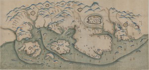
159、 廈門及鄰近地區地圖
CollectionAntique Maps of China Geographic region Xiamen (Fujian, China) Fujian Xiamen 廈門 福建 中國 Additional titles Manuscript map of Amoy and the surrounding region Map of Amoy and the surrounding region Note Scale not given Title supplied...
更多: 万方数据 抗日战争与近代中日关系文献数据平台 京东 知网万方 国图▪文津 国图 上海图书馆 籍合网
