


161、 Carte de l'entré de Macao avec la route des vaisseaux pour se rendre a Wampou et celle des Bateaux du pays pour aller par l'interieur a Quanton
CollectionAntique Maps of China Map makers Guignes, Chrétien-Louis-Joseph de, 1759-1845 Houdan, François d SubjectsNautical charts Geographic region Zhujiang Kou (Guangdong, China) Zhujiang Kou (Guangdong) Guangdong Zhujiang Kou 珠江口 廣東 中國...
更多: 万方数据 国图 抗日战争与近代中日关系文献数据平台 上海图书馆 孔夫子旧书网

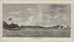
162、 View of Macao in China
CollectionAntique Maps of China Map makersLa Pérouse, Jean-François de Galaup, comte de, 1741-1788 SubjectsPictorial works Geographic region Macau (China : Special Administrative Region) Macau 澳門 Note "No 40" "de vancy delt "--Lower left c...
更多: 京东 抗日战争与近代中日关系文献数据平台 国图▪文津 籍合网 国图 上海图书馆

163、 Vüe de l'entrée du Bocca Tigris, conduisant à Canton
CollectionAntique Maps of China Map makersMeares, John, 1756 -1809 SubjectsPictorial works Geographic region Zhujiang Kou (Guangdong, China) Guangdong Zhujiang Kou 中國 廣東 珠江口 Note Appeared in: Meares French ed of Voyages made in the years 1...
164、 Vue de la ville de Macao
CollectionAntique Maps of China Map makersMeares, John, 1756 -1809 SubjectsPictorial works Geographic region Macau (China : Special Administrative Region) Macau 澳門 Note Appeared in: Meares French ed of Voyages made in the years 1788 and 17...
更多: 上海图书馆 万方数据 京东 抗日战争与近代中日关系文献数据平台 国图▪文津 国图

165、 Vue de l'ile Tiger, situee sur le Bocca Tigris, et nommee Tailoc Tow par les Chinois
CollectionAntique Maps of China Map makersMeares, John, 1756 -1809 SubjectsPictorial works Geographic region Zhujiang Kou (Guangdong, China) Guangdong Zhujiang Kou Note Appeared in: Meares French ed of Voyages made in the years 1788 and 17...
更多: 京东 籍合网 上海图书馆 万方数据 国图 孔夫子旧书网

166、 Pic de Lantao, pres de l'entree du Bocca Tigris dessine sur le lieu meme par T.S. Parry
CollectionAntique Maps of China Map makersMeares, John, 1756 -1809 SubjectsPictorial works Geographic region Lantau (Hong Kong, China) Hong Kong Lantau 大嶼山 香港 中國 Note Appeared in: Meares French ed of Voyages made in the years 1788 and 1789...
更多: 万方数据 京东 籍合网 上海图书馆 抗日战争与近代中日关系文献数据平台 国图▪文津 孔夫子旧书网 知网万方 国图

167、 Plan de la ville de Macao
CollectionAntique Maps of China Map makers Guignes, Chrétien-Louis-Joseph de, 1759-1845 Houdan, François d SubjectsNautical charts Geographic region Macau (China : Special Administrative Region) Macau (Special Administrative Region) Macau...
更多: 国图 知网万方 孔夫子旧书网 京东 抗日战争与近代中日关系文献数据平台 万方数据 国图▪文津 籍合网 上海图书馆

168、 Schets van Typa, of van Macao
CollectionAntique Maps of China Map makersCook, James, 1728-1779 SubjectsNautical charts Geographic region Macau (Special Administrative Region) 澳門 中國 China Note Scale [ca 1:96387] Relief shown by soundings Navigation chart LanguageDutch ...
更多: 抗日战争与近代中日关系文献数据平台 万方数据 孔夫子旧书网 国图▪文津 国图 籍合网 知网万方

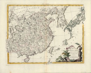
169、 Carte de la Chine : d'après les documens les plus authentiques
CollectionAntique Maps of China Map makersBrion de la Tour, Louis, -1823 Subjects Maps Early maps Geographic regionChina Additional titlesHistoire universelle, depuis le commencement du monde, jusqu à présent Note Scale not determined (E...
更多: 抗日战争与近代中日关系文献数据平台 国图 国图▪文津 上海图书馆 籍合网 万方数据

170、 A survey of the Tigris from Canton to the Island of Lankeet
CollectionAntique Maps of China Map makers Huddart, Joseph, 1741-1816 Sayer, Robert, 1725-1794 SubjectsNautical charts Geographic regionZhujiang Kou (Guangdong) Note Scale ca 1:97,000 Depth shown by soundings Dedicated to William Henry Pig...
更多: 知网万方 抗日战争与近代中日关系文献数据平台 万方数据 国图▪文津 国图 京东

171、 Sketch of the Typa and Macao
CollectionAntique Maps of China Map makers Cook, James, 1728-1779 Harrison, William, approximately 1750-1803 Subjects Cook, James, 1728-1779 Maps Nautical charts Travel Geographic region China Taipa Island Macau (China : Special Administ...
更多: 孔夫子旧书网 抗日战争与近代中日关系文献数据平台 上海图书馆 国图▪文津 籍合网 知网万方
172、 Impero della China colle Isole del Giappone
CollectionAntique Maps of China Map makersZatta, Antonio, active 1757-1797 Subjects Maps Early maps Geographic region China Japan Note Scale not given (E 120°--E 155°/N 40°--N 20°) Relief shown pictorially Call numberG7820 1784 Z3...
更多: 抗日战争与近代中日关系文献数据平台 知网万方 国图 上海图书馆 籍合网 国图▪文津

173、 L'Empire de la Chine : avec les isles du Japon
CollectionAntique Maps of China Map makersLattré, Jean Subjects Maps Early maps Geographic region China Japan Additional titlesPetit atlas moderne; ou, Collection de cartes elementaires Note Scale not determined (E 115°--E 155°/ N40°--N ...
更多: 知网万方 上海图书馆 万方数据 国图 国图▪文津 抗日战争与近代中日关系文献数据平台 京东 孔夫子旧书网 籍合网

174、 L'Asie divisée en ses principaux etats
CollectionAntique Maps of China Map makers Delamarche, Charles François, 1740-1817 Contained in (work): Lattré, Jean SubjectsMaps Geographic regionAsia Additional titlesPetit atlas moderne; ou, Collection de cartes elementaires Note Scal...
更多: 上海图书馆 万方数据 国图▪文津 抗日战争与近代中日关系文献数据平台 国图

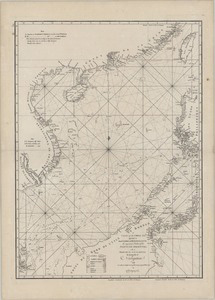
175、 A chart of the northern part of the China Sea : shewing the passage from Formosa to Japan with the Eastern coast of China and the Lekeyo Islands
CollectionAntique Maps of China Map makers Keulen, Gerard van Robert Sayer and John Bennett (Firm) Gaubil, Antoine, 1689-1759 SubjectsNautical charts Geographic regionChina Sea Note Scale ca 1:2,100,000 (E 118°45 --E 130°30 /N 35°--N 24°40...
更多: 万方数据 国图▪文津 籍合网 上海图书馆 国图 抗日战争与近代中日关系文献数据平台 孔夫子旧书网 知网万方

176、 Carte d'une partie des cotes de la Chine et des isles adjacentes
CollectionAntique Maps of China Map makers Dalrymple, Alexander, 1737-1808 Après de Mannevillette, Jean Baptiste Nicolas Dennis d , 1707-1780 SubjectsNautical charts Geographic region Zhujiang Kou (Guangdong) Zhujiang Kou (Guangdong, China...
更多: 国图▪文津 上海图书馆 知网万方 籍合网 孔夫子旧书网 万方数据
177、 A chart of the China Sea
CollectionAntique Maps of China Map makersDalrymple, Alexander, 1737-1808 SubjectsNautical charts Geographic region South China Sea Southeast Asia Note Scale ca 1:4,500,000 Relief shown by soundings Navigational chart LanguageEnglish Call...
更多: 抗日战争与近代中日关系文献数据平台 孔夫子旧书网 国图 籍合网 京东 万方数据 知网万方 上海图书馆

178、 Nouvelle carte de l'Empire de la Chine et les pais circonvoisins = Nieuwe kaart van't Keizerryk China en de aangrensende landen
CollectionAntique Maps of China Map makersTirion, Isaak, 1705-1769 SubjectsMaps Geographic region China Japan Additional titlesNieuwe kaart van t Keizerryk China en de aangrensende landen Note Scale approximately 1:20,000,000 (E 90°--E 170...
更多: 孔夫子旧书网 京东 籍合网 知网万方 国图▪文津 国图 抗日战争与近代中日关系文献数据平台 万方数据

179、 A correct chart of the China Seas containing the coasts of Tsiompa, Cochinchina, the Gulf of Tonquin, part of the coasts of China and the Philippin Islands
CollectionAntique Maps of China Map makersHerbert, William, 1718-1795 SubjectsNautical charts Geographic region South China Sea Philippines Vietnam, Southern Note Scale ca 1:3,000,000 Depth shown by soundings Hand colored Navigational char...
更多: 国图▪文津 国图 籍合网 京东 上海图书馆 抗日战争与近代中日关系文献数据平台
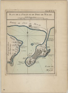
180、 Plan de la ville et du port de Macao
CollectionAntique Maps of China Map makersBellin, Jacques Nicolas, 1703-1772 SubjectsHarbors Geographic region Macau (China : Special Administrative Region) Macau (Special Administrative Region) Macau 澳門 中國 Note Scale ca 1:47,000 Relief sh...
更多: 国图▪文津 万方数据 知网万方 上海图书馆 籍合网 抗日战争与近代中日关系文献数据平台 京东 国图