


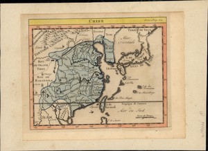
41、 A chart of the eastermost part of the East Indies and China from Cape Comarine to Iapan, with all the adjacent islands
CollectionAntiqueMapsofChinaMapmakersSeller,John,active1658-1698SubjectsNauticalchartsGeographicregionSoutheastAsiaAdditionaltitlesEastIndiesNoteScaleca1:11,600,000HandcoloredNavigationalchartInset:JapanLanguageEnglishCallnumberG8001P51702S...
更多: 孔夫子旧书网 国图 上海图书馆 知网万方 京东 籍合网 国图▪文津 抗日战争与近代中日关系文献数据平台 万方数据

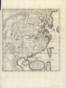
43、 Imperii Sinarum nova descriptio
CollectionAntiqueMapsofChinaMapmakersClüver,Philipp,1580-1622SubjectsMapsGeographicregionChinaNoteScaleapproximately1:14,300,000ReliefshownpictoriallyAppearsin:ClüversIntroductionisinuniversamgeographiam,[London,1711]Inupperleftcorner:Tab...
更多: 万方数据 籍合网 孔夫子旧书网 国图▪文津 抗日战争与近代中日关系文献数据平台 上海图书馆 知网万方 京东 国图

44、 Plan du fort de Zelande à l'Isle formose les Chinois appellent ce fort Ngan-ping-tching tiré par ordre de l'Empereur de la Chine
CollectionAntiqueMapsofChinaGeographicregionZeelandia(Taiwan:Fort)FortTaiwanZeelandia熱蘭遮城台灣NoteScaleindeterminable"Tom18,Pag343"Appearedinv18ofJesuitsLettresedifiantesetcurieusesLanguageFrenchCallnumberG7914T4:2Z41715P5DOI1014711/spcol/b654...
更多: 知网万方 孔夫子旧书网 籍合网 国图 京东 上海图书馆 万方数据 抗日战争与近代中日关系文献数据平台

45、 Il regno della China detto presentemente Catay e Mangin diuiso sopra le carte piu esatte nelle sue principali prouincie
CollectionAntiqueMapsofChinaMapmakersPetrini,PaoloSanson,GuillaumeGeographicregionChinaJapanEastAsia中國NoteScale[ca1:9,277,000](E135°--E195°/N20°--N45°)ReliefshownpictoriallyOutlinecoloredbyhandLanguageItalianCallnumberG78201717P48DOI1014711...
更多: 籍合网 上海图书馆 万方数据 国图▪文津 知网万方 国图 孔夫子旧书网 京东

46、 Carte des costes de l'Asie sur l'ocean contenant les bancs isles et costes & c levee sur les memoires les plus nouveau
CollectionAntiqueMapsofChinaMapmakersMortier,PierreSubjectsNauticalchartsGeographicregionSouthAsiaSoutheastAsiaPacificOceanNoteScalenotgivenHandcoloredNavigationalchartIncludesinsetonAustraliaTasmansdiscoveriesinAustralia1642-1644areshownin...
更多: 京东 籍合网 国图▪文津 上海图书馆 知网万方 万方数据

47、 Platte grond vande stadt Macao
CollectionAntiqueMapsofChinaMapmakersValentijn,François,1666-1727GeographicregionMacau(China:SpecialAdministrativeRegion)Macau澳門NotePublishedinValentijnsOudennieuwOost-IndiënLanguageDutchCallnumberG79451724V35DOI1014711/spcol/b537643...
更多: 国图▪文津 抗日战争与近代中日关系文献数据平台 知网万方 国图 上海图书馆 孔夫子旧书网
48、 Paradigma XV provinciarum et CLV urbium capitalium Sinensis Imperij cum templis quae cruce signantur et Domiciliis S.I
CollectionAntiqueMapsofChinaMapmakersCouplet,Philippe,1623-1692SubjectsMapsJesuitsMissionsHistory17thcenturyGeographicregionChinaNoteScalenotgivenReliefshownpictoriallyCallnumberG78201729C68...
更多: 籍合网 上海图书馆 知网万方 万方数据 京东 抗日战争与近代中日关系文献数据平台 国图▪文津

49、 The empire of China and Island of Japan, agreeable to modern history
CollectionAntiqueMapsofChinaMapmakersMoll,Herman,-1732SubjectsMapsGeographicregionChinaJapanNoteScaleapproximately1:1,750,000(E100°--E140°/N50°--N20°)ReliefshownpictoriallyInupperrightmargin:37CallnumberG78201735M6...
更多: 上海图书馆 京东 万方数据 籍合网 国图 抗日战争与近代中日关系文献数据平台 孔夫子旧书网 知网万方 国图▪文津

50、 Carte generale du Thibet ou Bout-tan et des pays de Kashgar et Hami : dressée sur les cartes et memoires des RR. PP. Jesuites de la Chine et accordée avec la situation constante de quelques pays voisins
CollectionAntiqueMapsofChinaMapmakersAnville,JeanBaptisteBourguignond,1697-1782GeographicregionXizangQinghaiXinjiangNoteScaleca1:5,000,000ReliefshownpictoriallyAppearedintheauthorsNouvelatlasdelaChine,1737CallnumberDS708D851737map32DOI10147...

51、 IIe. feuille particuliere de la Tartarie Chinoise contenant les environs de Nimgouta, qui est proprement l'ancien paÿs des Mantcheoux, et l'extremité la plus septentrionale de la Corée
CollectionAntiqueMapsofChinaMapmakersAnville,JeanBaptisteBourguignond,1697-1782GeographicregionChinaDongbeiDiqu中國東北地區Additionaltitles2efeuilleparticulieredelaTartarieChinoisecontenantlesenvironsdeNimgouta,quiestproprementlancienpaÿsdesMantc...
更多: 京东 抗日战争与近代中日关系文献数据平台 知网万方 籍合网 万方数据

52、 IVe. feuille comprise dans la carte générale du Thibet et qui contient en particulier le païs des Tartares de Hoho-nor
CollectionAntiqueMapsofChinaMapmakersAnville,JeanBaptisteBourguignond,1697-1782GeographicregionChinaXizangQinghai中國西藏青海Additionaltitles4efeuillecomprisedanslacartegénéraleduThibet,etquicontientenparticulierlepaïsdesTartaresdeHoho-norQuatriè...
更多: 孔夫子旧书网 上海图书馆 国图 万方数据 知网万方 国图▪文津

53、 IXe. et derniere feuille de celles qui sont comprises dans la carte generale du Thibet et ou se trouve Latac
CollectionAntiqueMapsofChinaMapmakersAnville,JeanBaptisteBourguignond,1697-1782GeographicregionChinaXizang中國西藏Additionaltitles9eetdernierefeuilledecellesquisontcomprisesdanslacartegeneraleduThibetetousetrouveLatacNeuvièmeetdernierefeuillede...
更多: 孔夫子旧书网 上海图书馆 国图▪文津 国图 知网万方 万方数据

54、 IXe. feuille particuliere de la Tartarie Chinoise ou ses limites avec la Tartarie Russienne sont exposés
CollectionAntiqueMapsofChinaMapmakersAnville,JeanBaptisteBourguignond,1697-1782GeographicregionChinaDongbeiDiqu中國東北地區Additionaltitles10efeuilleparticulieredelaTartarieChinoise,ouseslimitesaveclaTartarieRussiennesontexposésNeuvièmefeuillepar...
更多: 上海图书馆 国图▪文津 京东 国图 万方数据 孔夫子旧书网 抗日战争与近代中日关系文献数据平台 籍合网 知网万方

55、 Ire feuille comprise dans la carte générale du Thibet qui contient en particulier l'extremité Occidentale du grand Desert de Sable et le pays aux environs de Hami
CollectionAntiqueMapsofChinaMapmakersAnville,JeanBaptisteBourguignond,1697-1782GeographicregionChinaXizangXinjiang中國西藏新疆AdditionaltitlesPremièrefeuillecomprisedanslacartegénéraleduThibetquicontientenparticulierlextremitéOccidentaledugrandDe...
更多: 京东 籍合网 上海图书馆 孔夫子旧书网 抗日战争与近代中日关系文献数据平台

56、 Onzieme feuille particul. de la Tartarie Chinoise qui contient un pays dependant de la Russie au couchant de Niptchou
CollectionAntiqueMapsofChinaMapmakersAnville,JeanBaptisteBourguignond,1697-1782GeographicregionBaikal,Lake,Region(Russia)Baikal,Lake,RegionRussiaNoteScaleca1:2,000,000ReliefshownpictoriallyAppearedintheauthorsNouvelatlasdelaChine,1737Langua...
更多: 国图 抗日战争与近代中日关系文献数据平台 籍合网 上海图书馆 万方数据 孔夫子旧书网

57、 Opulentissimum Sinarum imperium juxta recentissimam delineationem in suas provincias disterminatum
CollectionAntiqueMapsofChinaMapmakersSeutter,Matthaeus,1678-1756GeographicregionChina中國NoteScaleca1cm=85GermanmilesHandcoloredReliefshownpictoriallyLanguageLatinCallnumberG78201737S48DOI1014711/spcol/b536718...
更多: 国图 京东 籍合网 万方数据 知网万方 抗日战争与近代中日关系文献数据平台 孔夫子旧书网 国图▪文津

58、 Province d'Yun-nan
CollectionAntiqueMapsofChinaMapmakersAnville,JeanBaptisteBourguignond,1697-1782GeographicregionChinaYunnan中國雲南NoteScaleca1:2,000,000ReliefshownpictoriallyHandcoloredcartoucheLanguageFrenchCallnumberDS708D851737map16DOI1014711/spcol/b649872...
更多: 上海图书馆 知网万方 万方数据 籍合网 国图 孔夫子旧书网 京东
59、 Province de Chan-si
CollectionAntiqueMapsofChinaMapmakersAnville,JeanBaptisteBourguignond,1697-1782GeographicregionChinaShanxi中國山西NoteScaleca1:2,000,000ReliefshownpictoriallyHandcoloredLanguageFrenchCallnumberDS708D851737map11DOI1014711/spcol/b649162...

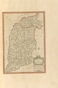
60、 Province de Chan-tong
CollectionAntiqueMapsofChinaMapmakersAnville,JeanBaptisteBourguignond,1697-1782GeographicregionChinaShandong中國山東NoteScaleca1:2,000,000ReliefshownpictoriallyHandcoloredAppearedintheauthorsNouvelatlasdelaChine,1737LanguageFrenchCallnumberDS70...
更多: 抗日战争与近代中日关系文献数据平台 万方数据 上海图书馆 知网万方 京东 国图