


61、 Province de Chen-si
CollectionAntiqueMapsofChinaMapmakersAnville,JeanBaptisteBourguignond,1697-1782GeographicregionChinaShaanxiGansuNoteScaleca1:2,000,000ReliefshownpictoriallyHandcoloredAppearedintheauthorsNouvelatlasdelaChine,1737LanguageFrenchCallnumberDS70...
更多: 万方数据 国图▪文津 京东 知网万方 国图 上海图书馆 孔夫子旧书网 抗日战争与近代中日关系文献数据平台

62、 Province de Kiang-nan
CollectionAntiqueMapsofChinaMapmakersAnville,JeanBaptisteBourguignond,1697-1782GeographicregionChinaJiangsuAnhuiNoteScaleca1:2,000,000ReliefshownpictoriallyHandcoloredAppearedintheauthorsNouvelatlasdelaChine,1737LanguageFrenchCallnumberDS70...
更多: 国图 籍合网 国图▪文津 抗日战争与近代中日关系文献数据平台 万方数据 孔夫子旧书网 上海图书馆 京东 知网万方

63、 Province de Quang-si
CollectionAntiqueMapsofChinaMapmakersAnville,JeanBaptisteBourguignond,1697-1782GeographicregionChinaGuangxi中國廣西NoteScaleca1:2,000,000ReliefshownpictoriallyHandcoloredcartoucheLanguageFrenchCallnumberDS708D851737map15DOI1014711/spcol/b649868...
更多: 籍合网 上海图书馆 孔夫子旧书网 抗日战争与近代中日关系文献数据平台 知网万方 京东 万方数据 国图 国图▪文津

64、 Province de Quang-tong
CollectionAntiqueMapsofChinaMapmakersAnville,JeanBaptisteBourguignond,1697-1782GeographicregionChinaGuangdongHainan中國廣東海南NoteScaleca1:2,000,000ReliefshownpictoriallyHandcoloredAppearedintheauthorsNouvelatlasdelaChine,1737LanguageFrenchCalln...
更多: 知网万方 籍合网 国图 孔夫子旧书网 抗日战争与近代中日关系文献数据平台 国图▪文津 上海图书馆 万方数据 京东

65、 Province de Se-tchuen
CollectionAntiqueMapsofChinaMapmakersAnville,JeanBaptisteBourguignond,1697-1782GeographicregionChinaSichuan中國四川NoteScaleca1:2,000,000ReliefshownpictoriallyHandcoloredAppearedintheauthorsNouvelatlasdelaChine,1737LanguageFrenchCallnumberDS708...
更多: 知网万方 孔夫子旧书网 国图▪文津 国图 万方数据 上海图书馆 抗日战争与近代中日关系文献数据平台 京东 籍合网

66、 VIIIe. feuille de la Tartarie Chinoise qui est le commencement du païs des Tartares Eluts, de l'extremité occidentale de celui des Kalkas
CollectionAntiqueMapsofChinaMapmakersAnville,JeanBaptisteBourguignond,1697-1782GeographicregionMongolia蒙古Additionaltitles8efeuilledelaTartarieChinoise,quiestlecommencementdupaïsdesTartaresEluts,delextremitéoccidentaledeceluidesKalkasHuitièm...
更多: 籍合网 抗日战争与近代中日关系文献数据平台 孔夫子旧书网 万方数据 国图▪文津 上海图书馆

67、 VIe. feuille particuliere de la Tartarie Chinoise contenant le païs des Tartares Yupi et Ilan-hala qui est de l'ancien païs Mantcheou
CollectionAntiqueMapsofChinaMapmakersAnville,JeanBaptisteBourguignond,1697-1782GeographicregionChinaHeilongjiangRussianFarEast(Russia)RussiaRussianFarEast中國黑龍江Additionaltitles6efeuilleparticulieredelaTartarieChinoise,contenantlepaïsdesTarta...
更多: 抗日战争与近代中日关系文献数据平台 国图▪文津 京东 知网万方 万方数据 籍合网 国图

68、 Ve. feuille de la Tartarie Chinoise contenant les environs de Tcitcicar et de Merguen, les Païs de Tagouri et des Solons, et l'extremité Orientale du grand désert de sable
CollectionAntiqueMapsofChinaMapmakersAnville,JeanBaptisteBourguignond,1697-1782GeographicregionChinaHeilongjiang中國黑龍江Additionaltitles5efeuilledelaTartarieChinoise,contenantlesenvironsdeTcitcicaretdeMerguen,lesPaïsdeTagourietdesSolons,etlext...
更多: 知网万方 籍合网 抗日战争与近代中日关系文献数据平台 京东 国图 国图▪文津

69、 Empire de la Chine
CollectionAntiqueMapsofChinaMapmakersRobertdeVaugondy,Gilles,1688-1766SubjectsMapsEarlymapsGeographicregionChinaAdditionaltitlesAtlasportatif,universeletmilitaireNoteScaleapproximately1:17,280,000(E116°--E145°/N40°--N20°)Reliefshownpictoria...

70、 L'empire de la Chine, dressé d'après les cartes de l'atlas chinois
CollectionAntiqueMapsofChinaMapmakersRobertdeVaugondy,Gilles,1688-1766RobertdeVaugondy,Didier,1723-1786GeographicregionChinaKorea中國NoteScaleca1:6,000,000ReliefshownpictoriallyFromAtlasuniversel,byGilles&DidierRobertdeVaugondy,1749-1792O...
更多: 籍合网 上海图书馆 国图▪文津 京东 抗日战争与近代中日关系文献数据平台 万方数据

71、 Karte von der Bay von Chin-chew oder Chang-chew, nebst den Eylanden Emowi und Quemowi
CollectionAntiqueMapsofChinaMapmakersBellin,JacquesNicolas,1703-1772GeographicregionChinaFujian中國福建NoteScaleca1:703,000Depthshownbysoundings"No49"LanguageGermanCallnumberG7823F81753B45DOI1014711/spcol/b534920...
更多: 万方数据 孔夫子旧书网 国图▪文津 籍合网 抗日战争与近代中日关系文献数据平台 知网万方

72、 Province II, Kyâng-nan
CollectionAntiqueMapsofChinaMapmakersBowen,Thomas,-1790Cave,Thomas,1712-1778SubjectsMapsEarlymapsGeographicregionChina,SoutheastNoteScalenotdetermined(E113°--E119°/N35°--N30°)ReliefshownpictoriallyInleftuppercorner:Vol1,pag73CallnumberG7822...
更多: 抗日战争与近代中日关系文献数据平台 籍合网 国图▪文津 京东 孔夫子旧书网

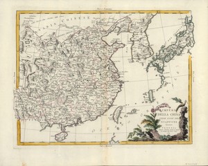
73、 L'Empire de la Chine : d'apres l'Atlas Chinois, avec les Isles du Japon
CollectionAntiqueMapsofChinaMapmakersBonne,Rigobert,1727-1794GeographicregionChinaJapanKoreaEastAsiaNoteScaleca1:8,000,000(E114°--E157°/N43°--N18°)HandcoloredReliefshownpictoriallyCallnumberG78201762B65DOI1014711/spcol/b535868...
更多: 万方数据 知网万方 抗日战争与近代中日关系文献数据平台 孔夫子旧书网 国图▪文津 国图

74、 Isle de Cheu-chan ou isle Chusan avec les costes et isles voisines
CollectionAntiqueMapsofChinaMapmakersBellin,JacquesNicolas,1703-1772GeographicregionZhoushanQundao(Zhejiang,China)ChinaZhejiangZhoushanQundao舟山群島浙江中國NoteScaleca1:568,000)Reliefshownpictorially;depthshownbysoundings"TomeIII,no61"HandcoloredL...
更多: 国图 籍合网 京东 国图▪文津 孔夫子旧书网 上海图书馆 知网万方
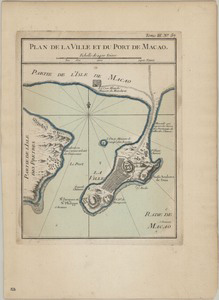
75、 Plan de la ville et du port de Macao
CollectionAntiqueMapsofChinaMapmakersBellin,JacquesNicolas,1703-1772SubjectsHarborsGeographicregionMacau(China:SpecialAdministrativeRegion)Macau(SpecialAdministrativeRegion)Macau澳門中國NoteScaleca1:47,000ReliefshownpictoriallyandbyhachuresTran...
更多: 万方数据 国图▪文津 籍合网 上海图书馆 国图 孔夫子旧书网 抗日战争与近代中日关系文献数据平台

76、 Nouvelle carte de l'Empire de la Chine et les pais circonvoisins = Nieuwe kaart van't Keizerryk China en de aangrensende landen
CollectionAntiqueMapsofChinaMapmakersTirion,Isaak,1705-1769SubjectsMapsGeographicregionChinaJapanAdditionaltitlesNieuwekaartvantKeizerrykChinaendeaangrensendelandenNoteScaleapproximately1:20,000,000(E90°--E170°/N60°--N20°)Reliefshownpictori...
更多: 国图 京东 知网万方 万方数据 抗日战争与近代中日关系文献数据平台 孔夫子旧书网 上海图书馆 籍合网
77、 A chart of the China Sea
CollectionAntiqueMapsofChinaMapmakersDalrymple,Alexander,1737-1808SubjectsNauticalchartsGeographicregionSouthChinaSeaSoutheastAsiaNoteScaleca1:4,500,000ReliefshownbysoundingsNavigationalchartLanguageEnglishCallnumberG8001P51774D35DOI1014711...
更多: 国图 上海图书馆 万方数据 籍合网 国图▪文津 抗日战争与近代中日关系文献数据平台 知网万方

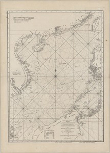
78、 A chart of the northern part of the China Sea : shewing the passage from Formosa to Japan with the Eastern coast of China and the Lekeyo Islands
CollectionAntiqueMapsofChinaMapmakersKeulen,GerardvanRobertSayerandJohnBennett(Firm)Gaubil,Antoine,1689-1759SubjectsNauticalchartsGeographicregionChinaSeaNoteScaleca1:2,100,000(E118°45--E130°30/N35°--N24°40)DepthshownbysoundingsNavigational...
更多: 国图▪文津 籍合网 抗日战争与近代中日关系文献数据平台 京东 孔夫子旧书网 上海图书馆
79、 Impero della China colle Isole del Giappone
CollectionAntiqueMapsofChinaMapmakersZatta,Antonio,active1757-1797SubjectsMapsEarlymapsGeographicregionChinaJapanNoteScalenotgiven(E120°--E155°/N40°--N20°)ReliefshownpictoriallyCallnumberG78201784Z3...
更多: 上海图书馆 抗日战争与近代中日关系文献数据平台 京东 国图 国图▪文津 万方数据 孔夫子旧书网

80、 Sketch of the Typa and Macao
CollectionAntiqueMapsofChinaMapmakersCook,James,1728-1779Harrison,William,approximately1750-1803SubjectsCook,James,1728-1779MapsNauticalchartsTravelGeographicregionChinaTaipaIslandMacau(China:SpecialAdministrativeRegion)Macau(SpecialAdminis...
更多: 抗日战争与近代中日关系文献数据平台 上海图书馆 国图▪文津 万方数据 国图 京东