


141、 China
CollectionAntique Maps of China Map makersMoll, Herman, -1732 Geographic regionChina Additional titlesAt top of map: The empire of China, and the land of Jeffo Note Scale not given (E 115°--E 150°/N 40°--N 20°) Relief shown pictorially Tex...
更多: 国图▪文津 知网万方 籍合网 上海图书馆 抗日战争与近代中日关系文献数据平台 孔夫子旧书网

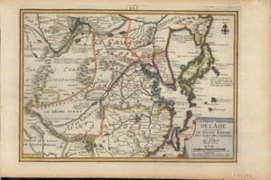
142、 La partie Orientale de L'Ásie : ou se trouvent le Grand Empire des Tartares Chinois et celuy du Iapon
CollectionAntique Maps of China Map makers Fer, Nicolas de, 1646-1720 Inselin, C Subjects Maps Early maps Geographic regionEast Asia Additional titlesSe trouvent le Grand Empire des Tartares Chinois et celuy du Iapon Note Scale not deter...
更多: 国图 孔夫子旧书网 京东 抗日战争与近代中日关系文献数据平台 知网万方
143、 La partie orientale de l'Asie ou se trouve le grand empire des Tartares chinois et celuy du Iapon
CollectionAntique Maps of China Map makers Fer, Nicolas de, 1646-1720 Inselin, C SubjectsMaps Geographic regionEast Asia Additional titlesAsie Note Scale ca 1:8,500,000 Relief shown pictorially "C Inselin sculpsit " In upper middle: 99 C...
更多: 知网万方 孔夫子旧书网 抗日战争与近代中日关系文献数据平台 京东 万方数据
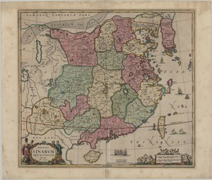
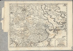
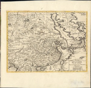
144、 Imperii Sinarum nova descriptio
CollectionAntique Maps of China Map makersLoon, J van, approximately 1611-1686 Geographic region China Korea 中國 Note Scale ca 1:6,000,000 Relief shown pictorially Hand colored LanguageLatin Call numberG7820 1709 L66 DOI10 14711/spcol/b535...

145、 La Chine : suivant les nouvelles observations de messrs. de l'Academie Royale des Sciences, etc
CollectionAntique Maps of China Map makersAa, Pieter van der, 1659-1733 Subjects Maps Early maps to 1800 Early maps Geographic region China Korea Note Scale not determined (E 120°--E 145°/N 40°--N 20°) Shows China and Korea Relief shown ...
更多: 知网万方 抗日战争与近代中日关系文献数据平台 国图 上海图书馆 孔夫子旧书网 国图▪文津 万方数据 籍合网
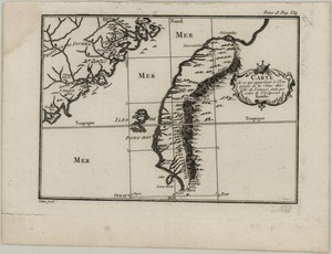
146、 Carte de ce qui appartient à l'Empereur de la Chine dans l'Ile de Formose
CollectionAntique Maps of China SubjectsCoasts Geographic region Taiwan China Fujian 台灣 中國 福建 Note Scale not given Relief shown pictorially "Tom 18, Pag 334 " LanguageFrench Call numberG7912 C74 1715 C3 DOI10 14711/spcol/b654165...
更多: 知网万方 抗日战争与近代中日关系文献数据平台 孔夫子旧书网 京东 万方数据 上海图书馆 籍合网
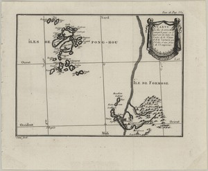
147、 Carte des Îles de Pong-hou suivant le point sur le quel ont été faites les Cartes de la Chine et de la Tartarie par l'Ordre et aux frais de l'Empereur
CollectionAntique Maps of China Geographic region Pʻeng-hu hsien (Taiwan) Pʻeng-hu hsien Taiwan 澎湖縣 台灣 Note Scale not given Relief shown pictorially "Tom 18, Pag 332 " LanguageFrench Call numberG7912 P4 1715 C3 DOI10 14711/spcol/b646291...
更多: 孔夫子旧书网 国图▪文津 知网万方 京东 抗日战争与近代中日关系文献数据平台 国图 籍合网 万方数据 上海图书馆

148、 A map of China drawn from those of the particular provinces made on the spot by the Jesuit missionaries
CollectionAntique Maps of China Map makersBowen, Emanuel, -1767 Geographic regionChina Note Scale not given Relief shown pictorially "E Bowen sculp " Prime meridian: Paris With text Library s copy with minor fold damages LanguageEnglish Ca...
更多: 知网万方 孔夫子旧书网 国图 抗日战争与近代中日关系文献数据平台 万方数据 籍合网 上海图书馆 京东
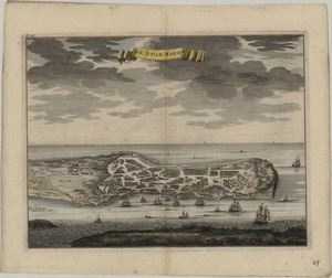
149、 De stad Macao
CollectionAntique Maps of China Map makersValentijn, François, 1666-1727 Geographic region Macau (China : Special Administrative Region) Macau 澳門 Note Hand colored "no 26"--Upper left corner Published in Valentijn s Oud en nieuw Oost-Indië...
更多: 国图▪文津 国图 孔夫子旧书网 抗日战争与近代中日关系文献数据平台 万方数据 上海图书馆 知网万方 籍合网 京东
150、 Nieuwe kaart van t keizerryk China en de aangrensende landen
CollectionAntique Maps of China Map makersTirion, Isaak, 1705-1769 SubjectsMaps Geographic region China Japan Note Scale approximately 1:20,000,000 (E 90°--E 170°/N60°--N 20°) Relief shown pictorially Call numberG7820 1729 T57...
更多: 孔夫子旧书网 上海图书馆 万方数据 籍合网 知网万方 国图▪文津
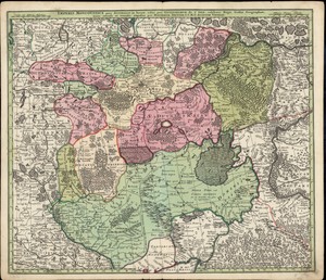
151、 Imperii Moscovitici pars Australis
CollectionAntique Maps of China Map makers Seutter, Matthaeus, 1678-1756 L Isle, Guillaume de, 1675-1726 SubjectsMaps Geographic regionRussia Note Scale indeterminate Relief shown pictorially Original old coloured map of the region around...
152、 La Chine : suivant les nouvelles observations de messrs. de l'Academie Royale des Sciences, etc
CollectionAntique Maps of China Map makersAa, Pieter van der, 1659-1733 SubjectsMaps Geographic region China Korea Note Scale not determined (E 120°--E 145°/N 40°--N 20°) Shows China and Korea Relief shown pictorially Call numberG7820 17...
更多: 国图 国图▪文津 籍合网 孔夫子旧书网 知网万方 上海图书馆 京东
153、 Nouvelle carte de l'empire de la Chine et les pais circonvoisins = Nieuwe kaart van t keizerryk China en de aangrensende landen
CollectionAntique Maps of China Map makersTirion, Isaak, 1705-1769 SubjectsMaps Geographic region China Japan Additional titlesNieuwe kaart van t keizerryk China en de aangrensende landen Note Scale approximately 1:20,000,000 (E 90°--E 170...
更多: 国图▪文津 知网万方 上海图书馆 孔夫子旧书网 籍合网

154、 Carte des pays traversés par le Capne Beerings depuis la ville de Tobolsk jusqu'a Kamtschatka
CollectionAntique Maps of China Map makers Anville, Jean Baptiste Bourguignon d , 1697-1782 Condet, Gerardus, 1715-1764 Geographic region Siberia (Russia) Russia Siberia Note Relief shown pictorially Appeared in the author s Nouvel atlas ...
更多: 京东 抗日战争与近代中日关系文献数据平台 国图▪文津 籍合网 国图 孔夫子旧书网 万方数据
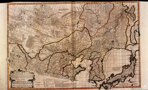
155、 Carte generale de la Tartarie Chinoise : dressée sur les cartes particulieres faites sur les lieux par les RR PP Jesuites et sur les Memoires particulieres du P. Gerbillon
CollectionAntique Maps of China Map makersAnville, Jean Baptiste Bourguignon d , 1697-1782 Geographic region Dongbei Diqu Mongolia Korea Japan Note Scale ca 1:5,000,000 Relief shown pictorially Hand colored Call numberDS708 D85 1737 map 1...
更多: 京东 上海图书馆 国图 孔夫子旧书网 国图▪文津 籍合网

156、 IIe. feuille comprise dans la carte générale du Thibet et qui contient en particulier le paÿs qui est au couchant de Tourfan
CollectionAntique Maps of China Map makersAnville, Jean Baptiste Bourguignon d , 1697-1782 Geographic region China Xizang Xinjiang 中國 西藏 新疆 Additional titles 2e feuille comprise dans la carte générale du Thibet et qui contient en particuli...
更多: 京东 万方数据 上海图书馆 国图 抗日战争与近代中日关系文献数据平台 国图▪文津 孔夫子旧书网 籍合网 知网万方

157、 IVe. feuille particuliere de la Tartarie Chinoise occupée par une partie du Cobi ou Cha-mo désert sablon[n]eux, jusques a la ville de Hami
CollectionAntique Maps of China Map makersAnville, Jean Baptiste Bourguignon d , 1697-1782 Geographic region China Nei Mongol Gobi Desert (Mongolia and China) Gobi Desert Mongolia and China 中國 內蒙古 戈壁沙漠 蒙古 Additional titles 4e feuille parti...
更多: 国图▪文津 万方数据 京东 孔夫子旧书网 抗日战争与近代中日关系文献数据平台 籍合网

158、 Ie. feuille de la Tartarie Chinoise, contenant le Leaotong et les environs de Kirin Oula, le Pays de Cartchin et autres quartiers des Mongous
CollectionAntique Maps of China Map makersAnville, Jean Baptiste Bourguignon d , 1697-1782 Geographic region China Liaoning Nei Mongol Jilin 中國 遼寧 內蒙古 吉林 Additional titles 1e feuille de la Tartarie Chinoise, contenant le Leaotong, et les e...
更多: 孔夫子旧书网 京东 国图 知网万方 上海图书馆 籍合网 国图▪文津 抗日战争与近代中日关系文献数据平台 万方数据

159、 Nouvel atlas de la Chine, de la Tartarie chinoise, et du Thibet : contenant les cartes générales & particulieres de ces pays, ainsi que la carte du royaume de Corée; la plupart levées sur les lieux par ordre de l'empereur Cang-Hi avec toute l'exactitude imaginable, soit par les PP. Jésuites missionaires à la Chine, soit par des Tartares du tribunal des mathématiques, & toutes revûës par les mêmes peres
CollectionAntique Maps of China Map makersAnville, Jean Baptiste Bourguignon d , 1697-1782 Geographic region China Xizang Korea Mongolia 中國 西藏 蒙古 Additional titlesAtlas de la Chine NoteHand colored LanguageFrench Call numberDS708 D85 1737 ...
更多: 国图▪文津 万方数据 知网万方 京东 籍合网 孔夫子旧书网 国图 上海图书馆
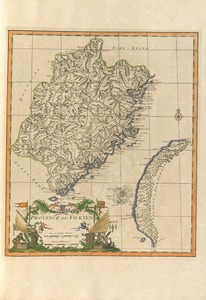
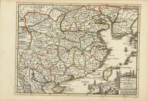
160、 Province de Fo-kien
CollectionAntique Maps of China Map makersAnville, Jean Baptiste Bourguignon d , 1697-1782 Geographic region China Fujian Taiwan 中國 福建 台灣 Note Scale ca 1:2,000,000 Relief shown pictorially Hand colored Appeared in the author s Nouvel atlas...